A History of Haven Green
John Rocque's Map 1741-5

Haven Green lies at a very ancient crossroads where tracks to Anglo-Saxon settlements at Twerverde (Twyford), Greneforde (Greenford), Hillindone (Hillingdon) and Northalla (Northolt) joined the old road from London to Uxbridge and Oxford.
Another ancient track ran south to Brentford where it would have joined the old London to Bristol road. Some think that after fording the Thames near Syon House, Julius Caesar may have travelled north along this route and passed through Haven Green on the way to battle the Catuvellauni peoples of Hertfordshire.
By the middle ages Uxbridge Road had become an important drovers’ road - the route along which sheep and other livestock were driven to market in London. This meant that Haven Green was perhaps one of the last stops for these animals on their way to slaughter. The right to use the land – then described as ‘the Haven’ - as common grazing was by then long established and it meant that the ‘free men’ of the area enjoyed rights to graze their animals or ‘bag a partridge’ on the Green
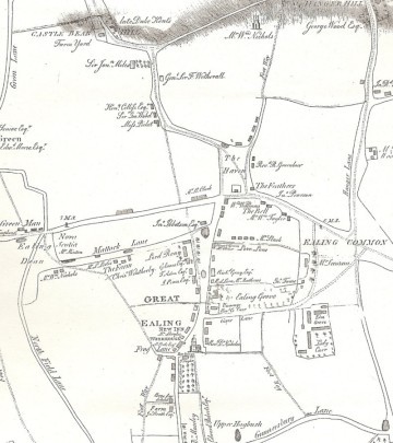
Until the 19th century, Haven Green lay outside the old Ealing Village which grew around St Mary’s church half a mile to the south. The parish map of 1823 shows the Green still mainly surrounded by open fields, but it would have been a busy place with inns like the Feathers (now the Town House) which dates at least from the 13th century and the Six Bells frequented by the drovers as their animals rested on the Green.
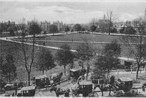
In 1838 Brunel’s Great Western Railway was constructed across the Green, cutting it in two, and a new station – Ealing Haven – was opened. Development around the Green accelerated during the second half of the 19th century as Ealing became a popular commuter suburb. The earliest surviving buildings on the Green are those of the Morton dental practice along the northern edge.
Ealing Local Board purchased Haven Green with other common land in 1878 to preserve it as public open space as London’s rapid spread threatened to cover all before it. Horse chestnuts were planted around the perimeter, and a walk lined with London plane trees was created along the south side.
The parish map from 1823 shows the Green, known then as the Haven, very recognisable as it is today. Castlebar and Mountpark Roads follow the old routes to the north with the former using the diagonal road that runs across the Green to this day.
 Scottish Dancing on the Green